Crew Access Aid Station Driving Directions
CCChapman Gulch (This information may be updated prior to run weekend)
4WD from Silverton
- Take US 550 west from the south end of Silverton.
- Near MP 75, turn west onto the Ophir Pass Road. This intersection is marked with a large green sign.
- Take the dirt road to Ophir Pass (11,800’). The road becomes noticeably rougher and steeper on the two-mile descent to the aid station at the south turnoff toward Swamp Gulch.
- Continue west past the intersection with the path where runners come out onto Ophir Pass Road. You must park in the designated lot in Ophir and hike back up Ophir Pass Road (1.75mi) to the aid station.
Alternate 2WD from Telluride
- Exit Telluride on Main Street and go west about three miles to SR 145.
- Turn left (S) and go about 10 miles to the Ophir Pass Road. This intersection is marked with a green sign.
- Turn left (E) passing through the hamlet of Ophir.
- You must park in the designated lot in Ophir and hike back up Ophir Pass Road (1.75mi) to the aid station.
No crew, spectator, media or parking or drop-offs of any kind will be allowed along Ophir Pass Road. We are serious, and penalties including disqualification and/or suspension from the lottery in future years can be applied to runners for non-compliance by their crews.
Telluride
- From the courthouse in Telluride, go east on Colorado Ave (the main street) to the Telluride town park area.
- Turn right and immediately cross the bridge toward the white canopy and baseball field.
Parking is limited both by the number of spots available and a two hour time restriction for occupying a spot. Crews who plan to spend more than two hours at the station should consider unloading their runner’s gear and finding a spot back east of the river. Be aware that parking on most streets in Telluride requires a paid stamp - the machines are to be found in most blocks. Pacers may not leave their vehicles at the aid station.
Ouray
- Take US 550 over Red Mountain Pass to Ouray.
- Go to the north end of the main business district, and turn left (West) on 9th Ave.
- Follow it 2 blocks, after which it will curve to the right (North).
- Continue straight, and park in the gravel lot designated for RV parking to your right. The lot may fill, in which case use streetside parking around town, being respectful of local residents and driveways. Please avoid using the Ouray Hot Springs parking lot before 10:00p
The aid station will be on the west side of the park between the gazebo and restrooms.
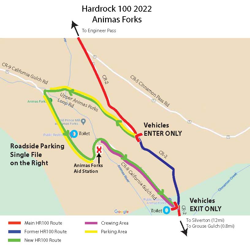
Animas Forks
- Take CR 2 NE from Silverton about 11 miles to a sign for Animas Forks / CR 9.
- Go beyond that sign 0.3mi to the next left, onto the upper Animas Forks Loop Road.
- Follow the loop road around through the town. Vehicle traffic will be one way only, downhill. Parking will be single file on the right hand side of the road, beginning just back of the Animas River bridge on the lower half of the loop. Follow the directions of parking marshals.
4WD Strongly Recommended Only one vehicle per runner will be allowed to park at Animas Forks. You must have your runner’s hangtag. Pacers may not leave their vehicles at the aid station.
Sherman
4WD from Silverton
- Take CR 2 NE from Silverton to Animas Forks (~11 miles)
- Continue on county roads over Cinnamon Pass (~5 miles beyond Animas Forks).
- From Cinnamon Pass, continue east toward Lake City approximately 15 miles past the Burrows Park Aid Station (no crews allowed) to the Sherman turn-off.
- Turn sharply right (W) on the Sherman road, one mile to the BLM latrine and Cataract Gulch trailhead where the aid station is located.
Alternate 2WD from Lake City
- From Lake City, take SR 149 south to the turnoff to Lake San Cristobol Road.
- Turn on the Lake San Cristobol Road and continue past the lake to the end of the pavement.
- Continue on CR 30 about 14 miles to signed turnoff to Sherman.
- Go one mile to the BLM latrine and the Cataract Gulch trailhead where the aid station is located.
Cunningham Gulch
- Take CR 2 NE from Silverton 4 miles to Cunningham Gulch following the signs to the Old Hundred Mine Tour.
- Just after crossing the Animas River Bridge at Howardsville, turn right (South) up the valley toward Stony Pass.
- At 2mi past the turn, DO NOT turn left onto the Stony Pass Road, but instead angle Right (Southwest) toward the Highland Mary trailhead.
- At 2mi beyond the Stony Pass Road, go past the Corral on your right to a large clearing. The aid station is in the clearing between the road and the creek.
Parking will likely be limited to one side of the road. Follow the signage and instructions.